DISCLOSURE: If I link to relevant products or helpful info it may be an affiliate link, meaning I may earn a small commission. As an Amazon Associate & other affiliate, I earn from qualifying purchases at no extra charge to you. The views & opinions are my own. Please see the disclaimer and privacy policy.
Last Updated on February 24, 2024
Wait! What is Ring Road in Iceland?
Ring Road, Route 1, is Iceland’s national roadway that loops around the country and connects all the major towns. The two-lane paved road circles the island for 828 miles and is the longest road in the country. It passes most of the country’s extraordinary sites including waterfalls, beaches, and glaciers, allowing you to photograph some unbelievable shots.
We took 2 days and toured the Southern route on Ring Road in Iceland with our self-drive itinerary, but could have used a week or more to enjoy everything to its fullest. The main road is easy to navigate for a do-it-yourself trip or make it simple and add a Southern Iceland tour from Rekjavik so that there is absolutely no hassle and you can sit back and let the guide do all the itinerary planning!.
Click here if you are TRAVELING TO ICELAND IN WINTER and need some winter driving and travel advice.
12 Awesome Attractions on the South Coast of Iceland on Ring Road

Seljalandsfoss Waterfall
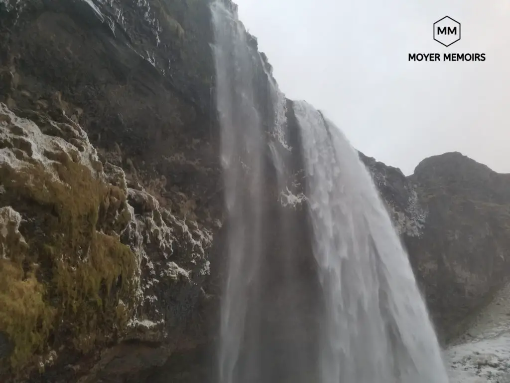
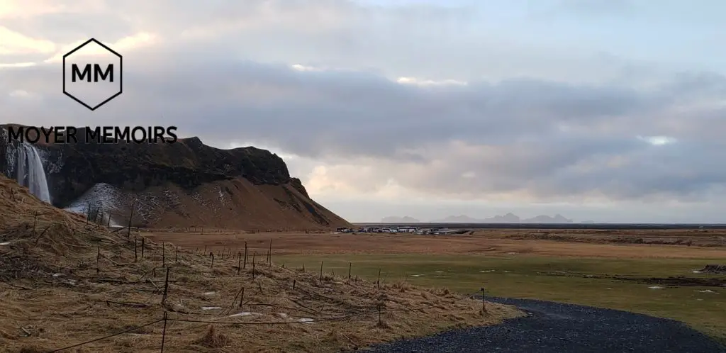
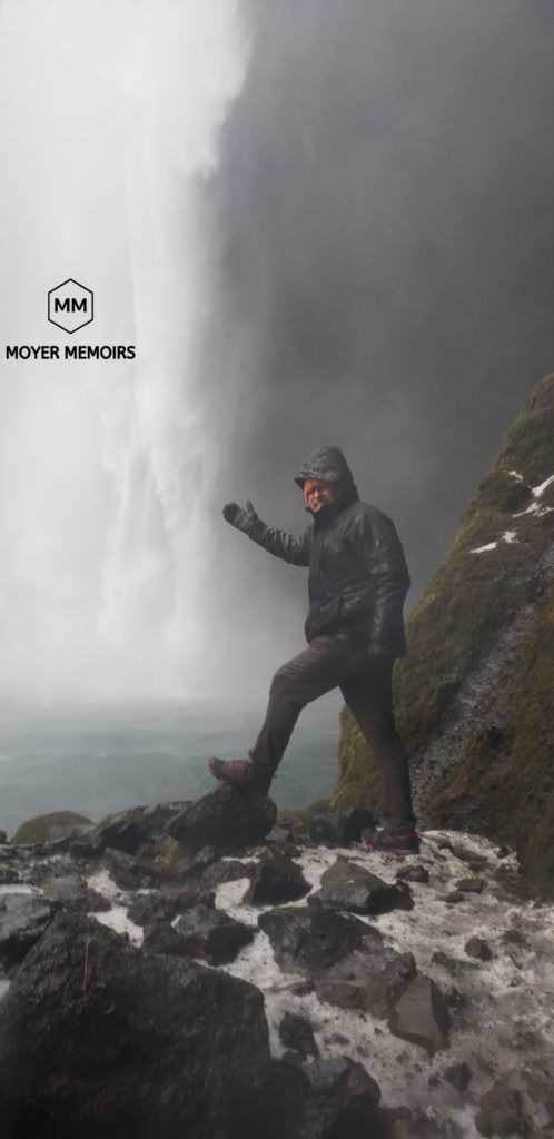
The southern Iceland Ring Road trip starts with a bang at Seljalandsfoss. This waterfall can be seen from Ring Road day –or night since it is lit up. It is nearly 200 feet high so it comes crashing down with the water supplied from run-off from the glaciers on top of Eyjafjallajokull volcano.
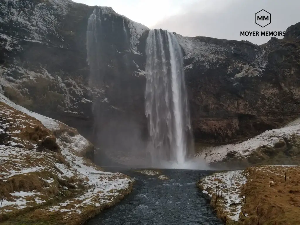
There is a high cliff and a path behind this waterfall that is open in the summer so that you can get a 360-degree unique panoramic view of it. How often can you take a scenic shot on the backside of a waterfall!? –You will just get a little bit wet while doing it so make sure you bring rain gear and protection for your photography equipment. You will need this WATERPROOF PROTECTIVE CASE for your phone so that you can still safely snap your selfies.
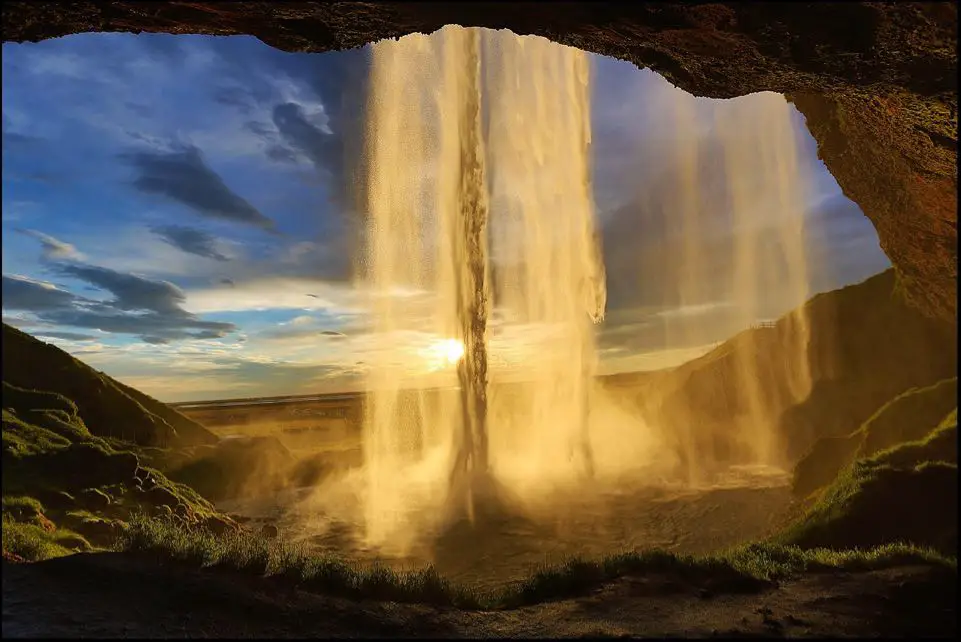
Access to the waterfall is pretty close, even in the winter when the main path is closed. Rain gear is a must and clampons are suggested for safety reasons. How many layers do you think I am wearing!!!???
–Clampons are the little spikes to put on the bottom of your shoes. GET A CHEAP PAIR OF CLAMPONS HERE. They are small and easily packed in your day bag.
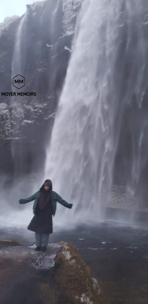
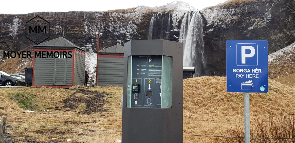
The surroundings are beautiful and full of wildflowers in the summer due to all the mist. This is a great location for an impromptu picnic. Wear clampons because the mist from the waterfall freezes and makes the paths and the stairs to the higher viewpoint extremely slippery. There is pay parking at the handy kiosk, toilets (you can change out of wet clothes here, but the space is very small!), and food available.
There is also a high viewpoint for Seljalandsfoss that is located across the bridge. The viewing platform is accessible from a tall, often icy, staircase. Going up to this platform will allow spectacular photos of the other side of the waterfall and the surrounding area. You will also get some looks of pure astonishment, like my hubby, when you scale that icy stairway effortlessly in your clampons!
Access to Seljalandsfoss waterfall is off of Ring Road, Iceland’s main thoroughfare. It is the first attraction on most Southern Iceland tour routes and is often included in the Golden Circle Tour.
You can see the GOLDEN CIRCLE IN A DAY.
Take a look at my Tips to Self Drive the Golden Circle Iceland Driving Route.
Gljufrabui Waterfall
A short walk across the bridge and past the Seljalandsfoss viewing platform is a “secret” waterfall. Gljufrabui, “Canyon Dweller,” is 131 feet high and hidden away for those that are interested in a more peaceful observation of nature.
There is a sign pointing toward it, but not many tourists venture to this one because of its effective hiding place, or maybe because it is a little more challenging to get to.
Along the path to Gljufrabui, you will pass several small trickles coming down from the cliffs, but keep going. When we were there in the winter, there was even a large pond that spanned the front of the cliffs. We stood and watched the fish swim this way and that and wondered how far they actually ventured.
You can only see the top of this Gljufrabui Waterfall from the front unless you are adventurous and decide to enter between the walls of rock.
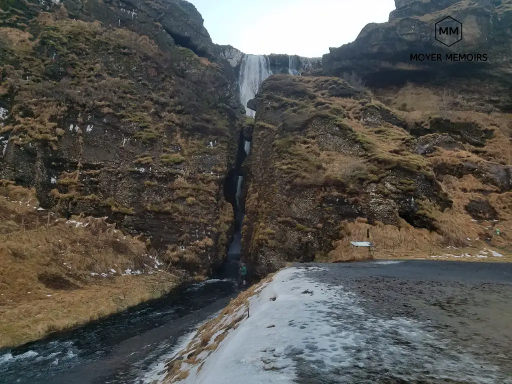
To enter this narrow canyon, you will need to walk through the cavern stream, so wear waterproof shoes. If the water is low, you may be able to balance on the rocks for about 10 feet and enter all the way without getting totally soaked… well your feet anyway, the rest of you will be soaked from the waterfall mist that totally fills the cavern. –but the bonus is that you will probably be the only ones in the cave, so you will have all the photography rights of the full view of Gljufrabui Waterfall to yourself!
Don’t want the hassle of driving and planning your Iceland South Coast tour? Take an excellent Guided Tour!
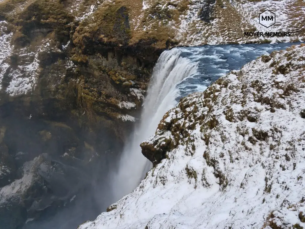
Skogafoss Waterfall
Yes, another waterfall! One of the biggest and most beautiful waterfalls in Iceland is Skogafoss. Yes, I know, up for debate! Iceland has so many waterfalls that everyone claims their own favorites!
This powerful cascade is 82 feet wide and drops off the cliffs at 197 feet high from the previous Iceland southern coastline. The coastline has moved back over 3 miles, leaving this beautiful waterfall in its path. Skogafoss is fed by two glaciers, Eyjafjallajokull and Myrdalsjokull.
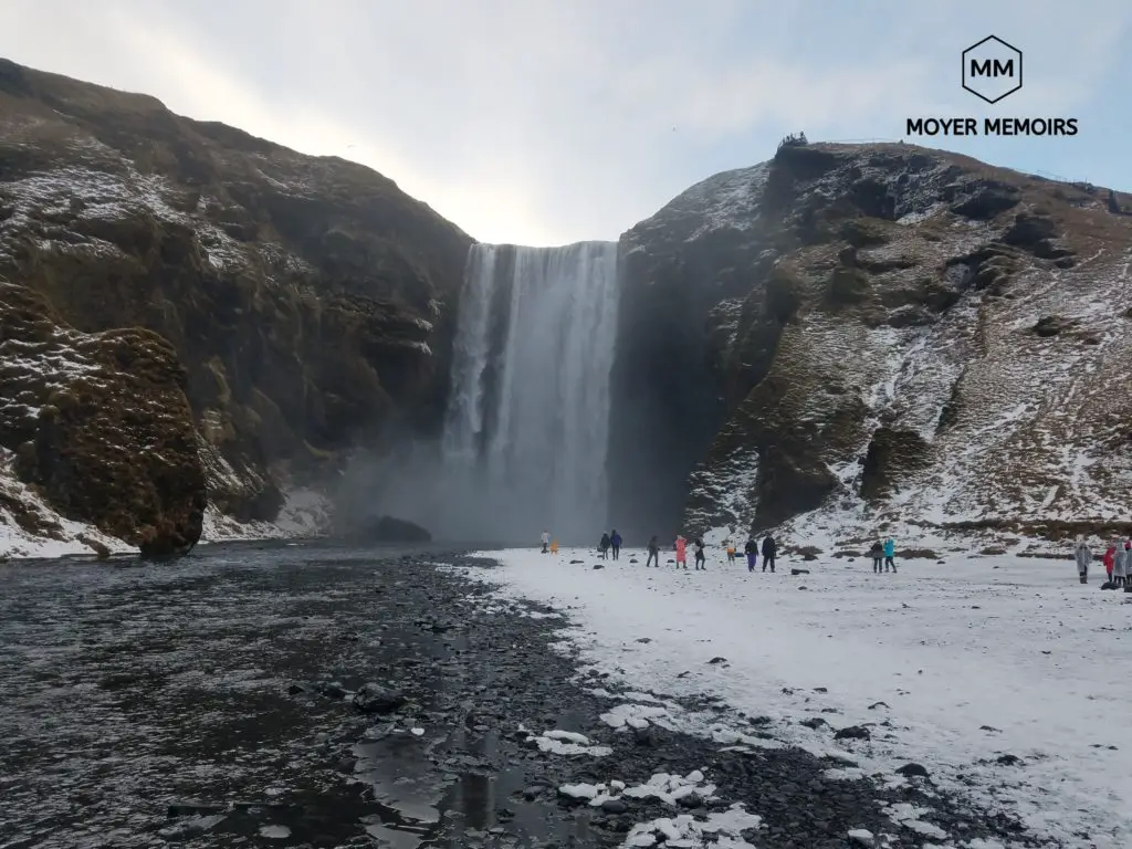
The river below the waterfall is full of char and salmon and is a favorite fishing hole during the summertime. The mighty waterfall produces a lot of mist, usually resulting in one or even two rainbows any time the sun is out. (It was actually raining when we were there, so no rainbows for us!) —oh and wear your raingear to protect against all the mist, especially since you can basically walk right up to this waterfall.
There is a viewing platform at the top of a 370-step wooden staircase. Attempt this feat only in good health and with sure footing because there are no rest stops on the staircase and often no side handrails to hold onto. While on your way up, you will probably see many nesting birds in the grassy areas in the summertime.
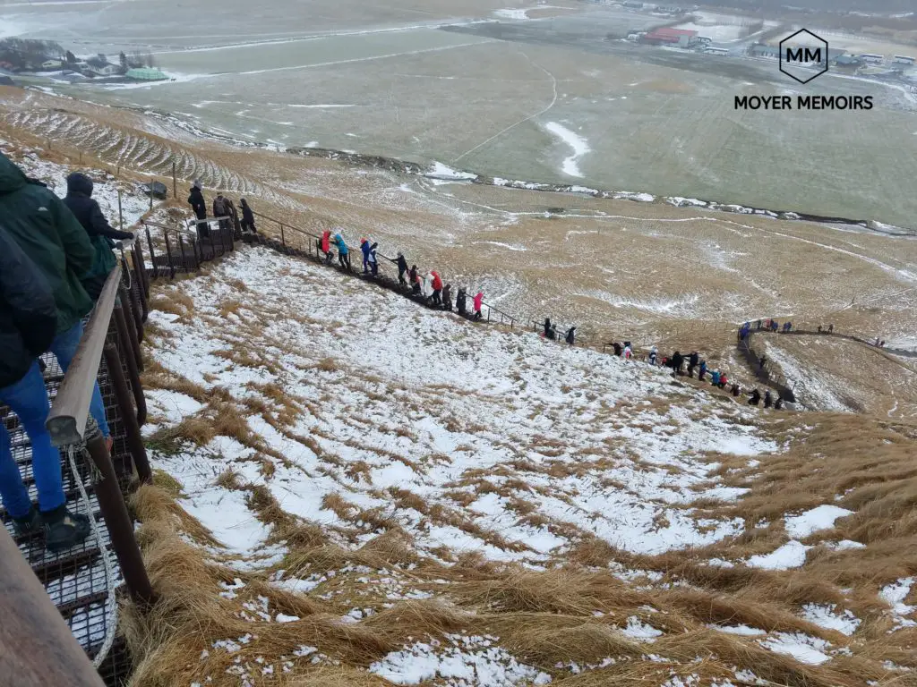
At the top of the staircase, you will definitely be rewarded with a stunning view from the top of the waterfall as well as a view of the southern coastline. My hubby claims this is his favorite Iceland photograph site.
Fimmvorduhals – Skogafoss hiking trail
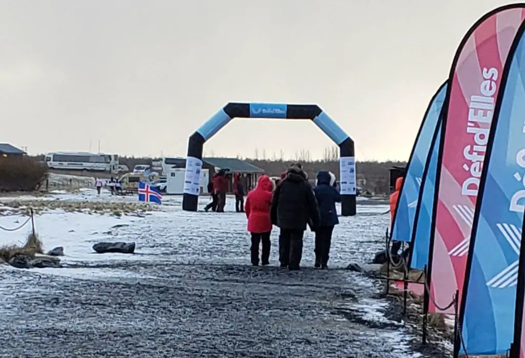
Also at the top of the staircase is the start –or end—of a very popular hiking route, Fimmvorduhals Pass. This 15 ½ mile trail can be done in a long day, travels along the Skoga River, passes between the two mighty glaciers that feed Skogafoss, and is only open in the summer. However, when we were there in the winter, there was a marathon going on this trail. The finish line was down the trail, down the steps, and to the front of Skogafoss Waterfall!
Legend of Gold at Skogafoss
According to legend, one of the first Viking settlers hid his hoarded gold buried behind Skogafoss Waterfall. There is a golden ring on display at the Skogafoss Museum which many believe broke off of the treasure chest when locals grasped it and tried to retrieve it. The chest itself has not been recovered.
Skogar
Skogafoss is located near the town of Skogar, home to the Skogar Museum, which is a collection of historical buildings and museum sites, the newest being the Transportation Museum. The Museum of Transportation focuses on how Iceland has transitioned from the days of horse and ferry transport. The museum also includes a shop and café and would be a nice break from the elements on a wintery Icelandic day.
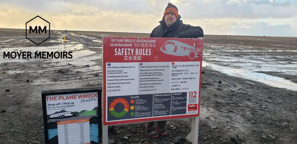
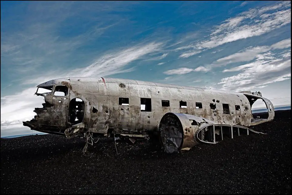
Solheimasander Plane Crash Site
This US Navy plane ran out of gas and crashed on the beach in 1973. There were no fatalities but they just left the wreckage there abandoned on the black sand, much to the Instagrammer’s delight. It is being worn out by the sand and wind, becoming just a skeleton of a military plane. It is still safe to touch and take pictures for the moment, although not recommended for climbing in case you fall through the worn-out metal. Although we did see a dude hoist his BMX bike onto the top of it so that he could get some wheelie shots!
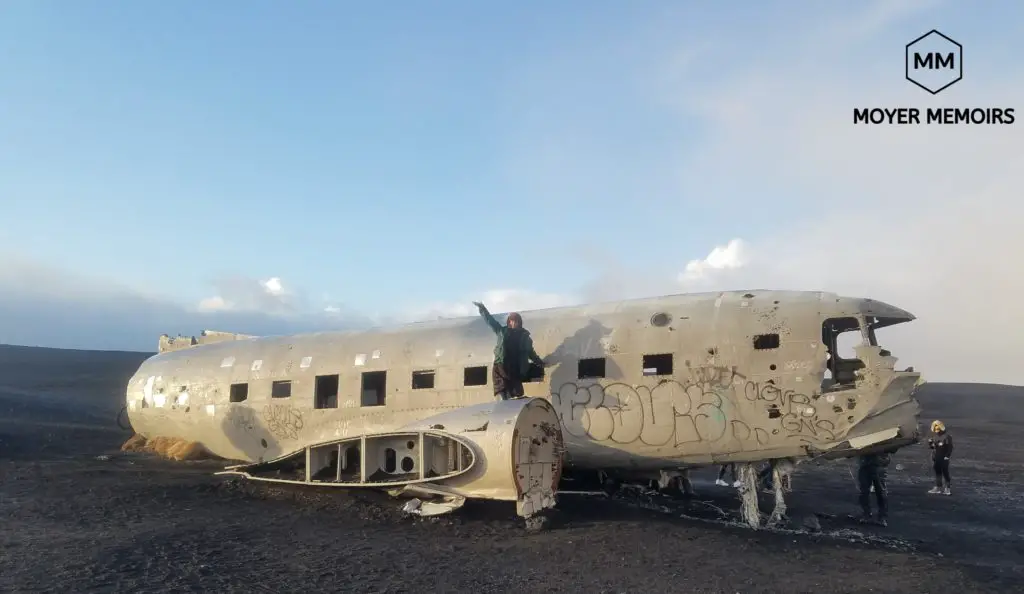
The Solheimasander parking lot is over a 3-mile roundtrip hike from the plane, but there is a shuttle that runs every-so-often. You can pay for a round-trip ticket to save some time—which is important especially if you are touring in the winter when there is limited daylight. You don’t want to be there in the dark and not be able to find your way back in the endless sand.
Dyrholaey
Dyrholaey, “the hill island with the door hole,” used to be an island, but is now a small peninsula on the south coast of Iceland. When driving along Ring Road, Dyrholaey is located at a turnoff at the end of the road on road 218, right before Black Sand Beach and Reynisfjall. There are two different paths on road 218 that you can take to Dyrholaey, the higher path or the lower path.
High Viewpoint at Dyrholaey
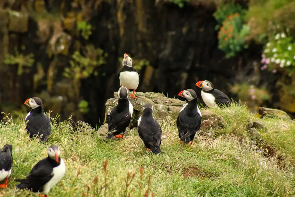
There is a higher viewpoint that offers breathtaking views of the Black Sand Beach, black basalt lava columns, Reynisdranger Mountain, Katla volcano, and Myrdalsjokull glacier. In the summer, the viewpoint is a bird hangout for adorable puffins. They make their nests in the natural habitat on the grassy hills. This is a great location for birding since you will definitely encounter some awesome photo opportunities between the puffins and the arctic terns that also make their nests there. This section is closed to the public at night (7pm – 9am) during the nesting season (typically May – June) to give them privacy to do their business (!!!).
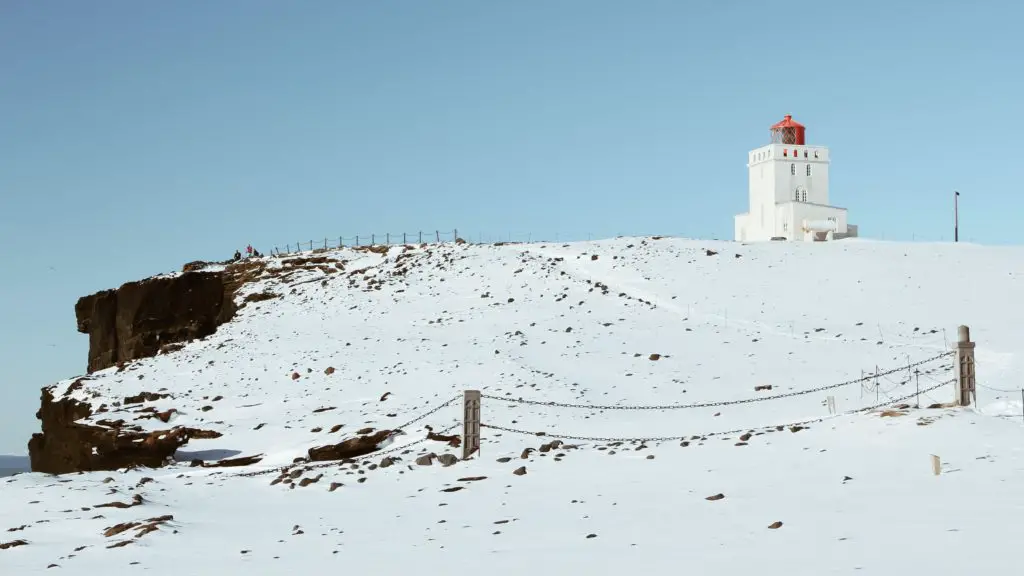
There is a century-old lighthouse up there that has become a cute and popular photography subject for tourists. It has been renovated into a private luxury hotel. Out of my price range!
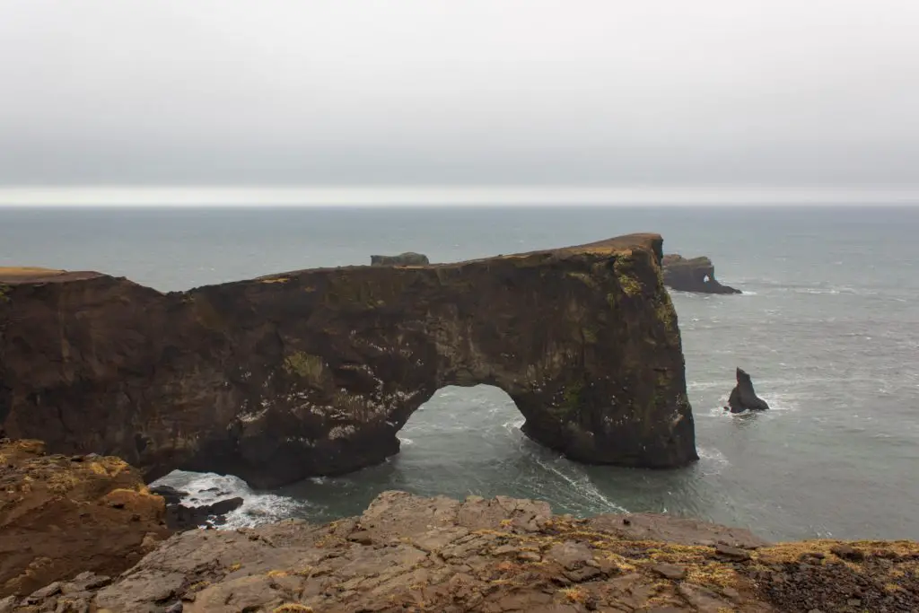
Lower Area at Dyrholaey
Following the lower path will take you to a black sand beach and the arch. Dyrholaey Arch is a natural black basalt arch, worn away by the strong ocean waves, and the main feature that adorns the island. It stands almost 400 feet high, so large that ships and small airplanes are said to be able to go through it. Also, keep an eye on the water around the arch since many seals are usually swimming about.
Reynisfjara
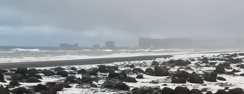
Just past Dyrholaey is Iceland’s most famous beach. It is nicknamed Black Sand Beach due to the ground up volcanic rock that has formed from lava that has cooled and solidified. The blackness is mouth-dropping, ominous, and quite a contrast to the tropical white sandy beaches in other destinations. The powerful waves provide a striking background to the deep endless black lava sand, making it an award-winning top ten finalist for the most beautiful non-tropical beaches in the world and a unique movie filming location for other-worldly shows like Star Wars and Game of Thrones.
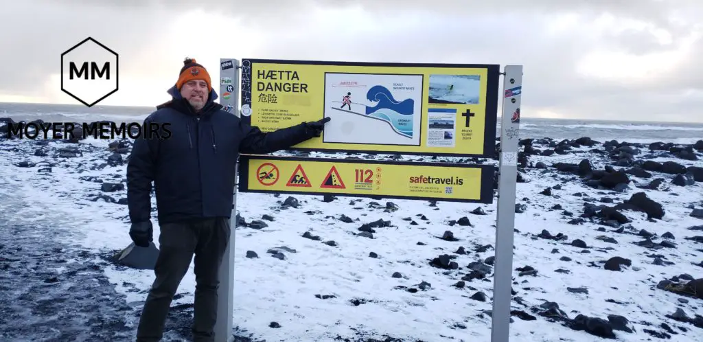
The huge waves from the Atlantic Ocean crashing to the shore are quite dangerous. There are signs posted everywhere warning of “sneaker waves.” The signs warn visitors to never turn away from the water, as an unexpected wave can crash way beyond the waterline, sneak up, and drag them out to sea while the strong current will prevent any return to shore. The huge waves crashing from the Atlantic Ocean gather force as they travel unobstructed by landmass all the way from Antarctica before pounding the Iceland coast, so no wonder they are so enormous.
Reynisdrangar Sea Stacks
From the black sandy shore, visitors have a great view of the Reynisdrangar sea stacks that are a group of three giant spikey basalt rock pillars sticking out high from the water. They are visible from both Vik and Dyrholaey since they pierce the sky at almost 200 feet high.
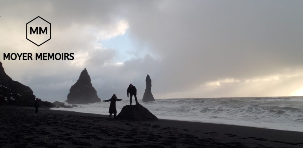
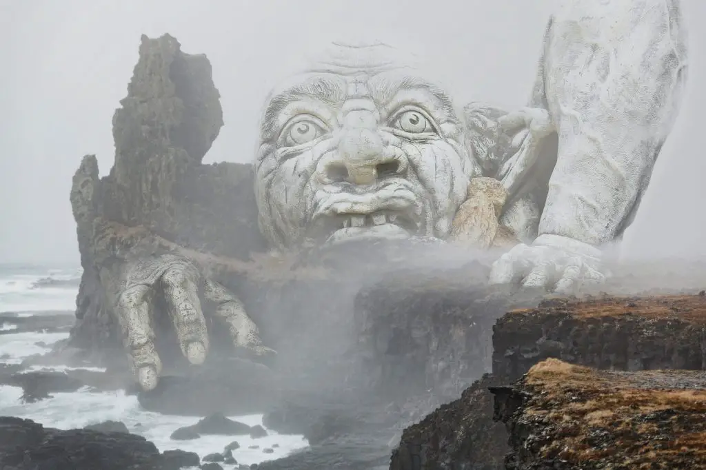
Legend says that they used to be trolls that came to the mountain, didn’t make it back in time for the sunrise, and are now preserved and petrified forever. Or, perhaps more realistically, they used to be a part of the mountain range on the south coast and were spared and not destroyed by the monster ocean waves. You can be the judge.
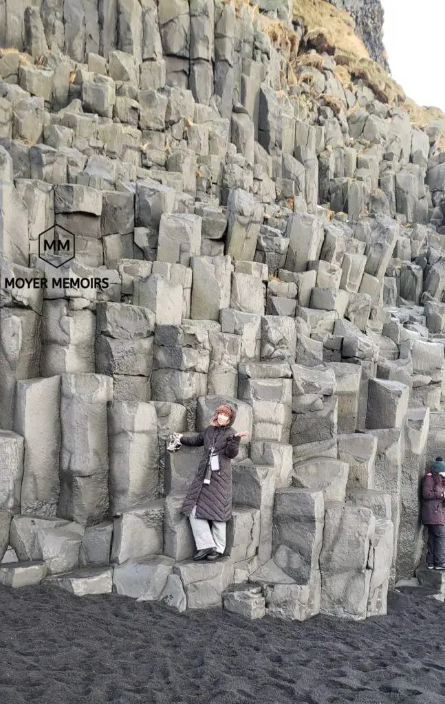
Basalt Columns
Behind us, as we stared at the vicious waves beating the shore, were the basalt columns, geometric lava shapes molded into smooth, high columns. They resembled the pipes for an organ and it was difficult to imagine how these magical hexagonal shapes were made naturally by Mother Nature. Somehow the whole process of columnar joining in cooling lava rock can be explained by modern physics and temperature gradients, but it is all over my pay grade.
Check this out if you need those GEEKY SCIENCE DETAILS ON COLUMNAR JOINING.
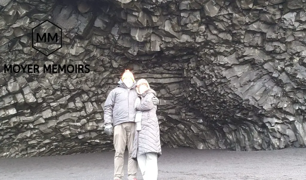
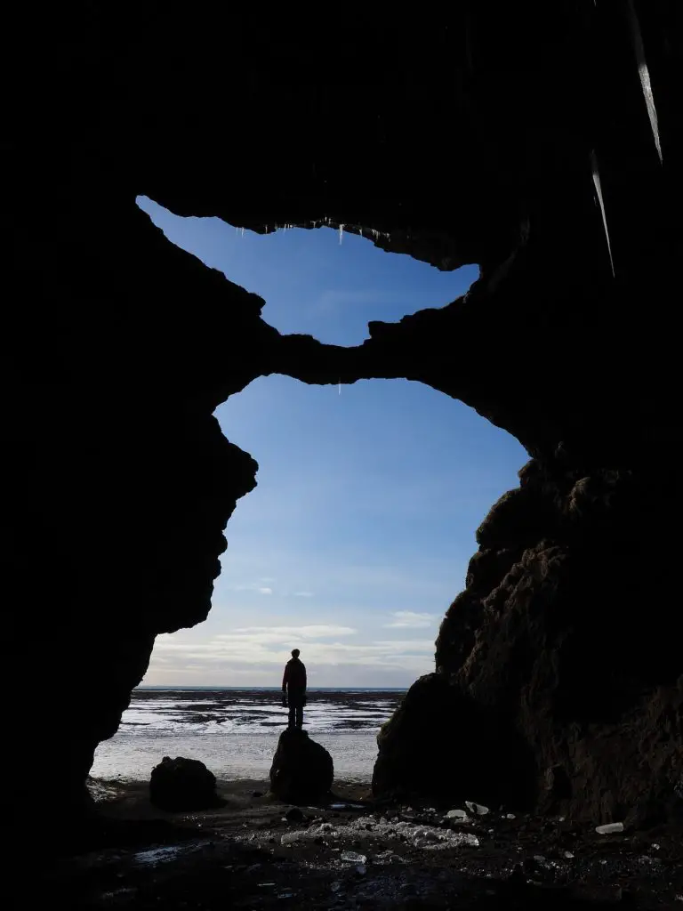
Halsanefshellir Cave
Carved out in the middle of the organ pipe basalt columns is a foreboding sea cavern, right on the black beach. It is about 10 feet high, dimly lit, and constantly supplied with water dripping from the seemingly suspended chandelier shapes on the ceiling. It is perfect for selfies, just bury your selfie stick in the black sand in front of it and smile! You will need to fidget with the settings since you will be a very bright silhouette in the dark cave. Maybe this is where the trolls used to live?
Reynisfjall Mountain
The mountain behind all the black sand and basalt arrangements is Reynisfjall. It stands at 1100 feet tall and stands watch over the beach. It was created in a volcanic eruption in the Ice Age and has had many birthdays go by.
From the shore, you’ll also have spectacular views of the arched cliff of Dyrhólaey that you just came from, filled with cute puffins in the summer.
Black Beach Restaurant is located near the beach. They serve light meals and even have pay toilets located outside for those not wanting to order any coffee. Additionally, the small town of Vik is a short drive away and it is filled with cute little eateries to satisfy your hungry.
Vik
Driving further along Ring Road, you will FINALLY come to a little village –civilization at last! –that is located halfway on the south coast, uniting the east and the west. If you have been driving the Ring Road for a while, you have likely noticed that there are not many towns around.
Vik has a population of 300 inhabitants and is the only town for at least 30 miles in either direction on Ring Road, so it has earned a reputation as a stop-over for tourists. Definitely plan to stop here at this picturesque little settlement to fuel up your car, fuel up your belly, and see some sites because there is a little bit more to it than just a quick rest stop.
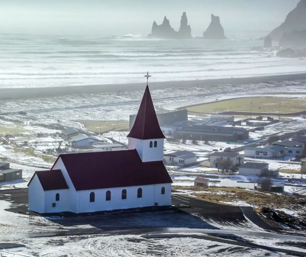
Víkurkirkja
The most famous and most photographed landmark in Vik is the red-roofed church with all its stained glass windows. It was built in 1934 on a hill, high above town, and offers great panoramic views of the town.
Sundlaugin
If you need a break from driving, you can stop at Vik’s outdoor swimming pool. It is open all year and geothermally heated for a cozy experience no matter what the weather outside is.
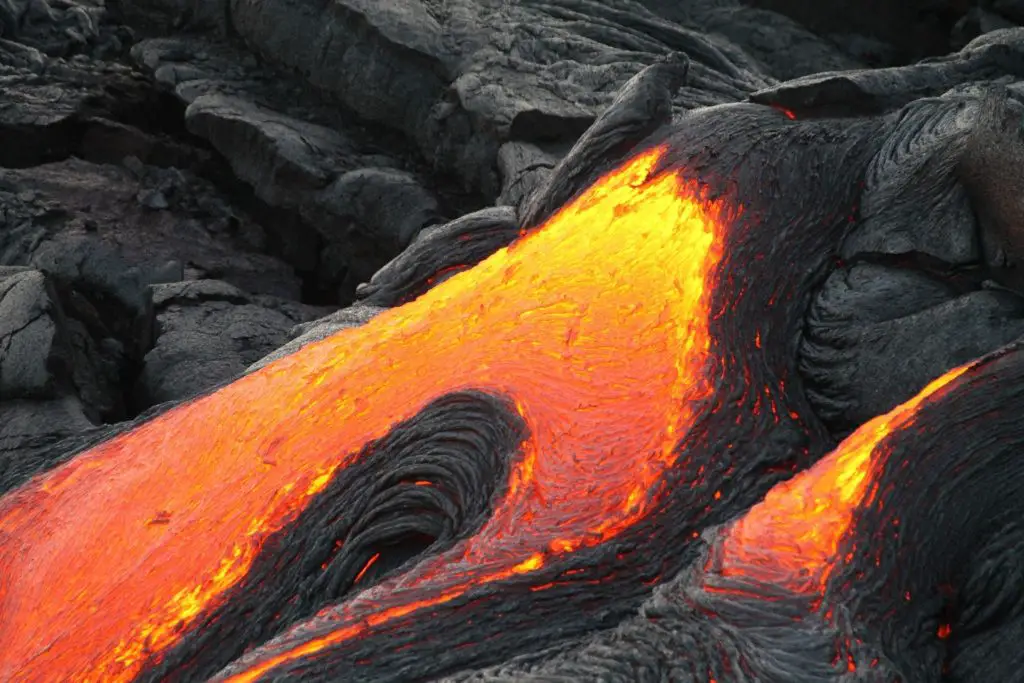
Icelandic Lava show
This show in the Land of Fire and Ice is so unique. It is the only show in the world where you can safely and closely experience red-hot lava, see it flowing, hear it sizzling, and feel the heat that radiates from it. The volcanic eruption during these educational shows happens every day and is unlike anything you have experienced before.
Wool Gallery
This cute little souvenir shop is a must-see if Icelandic wool purchases like hats, gloves or scarfs are your desired souvenir during your trip to Iceland. It is located in a converted army container near the Information Center in Vik.

Vik Wool Vikurprjon
—And then there is the mega souvenir store in the center of town! All tours stop here before passing through Vik. This store has every souvenir imaginable. If you don’t have time to shop through the little stores in Reykjavik, make sure to pay this place a visit to get it all done in one place.

Hjorleifshofki
Hjörleifshöfði is an enormous rock, and a mouthful if you try to pronounce it. It is 725 ft in elevation, located in southern Iceland, and was formed in a volcanic eruption underneath a glacier during the ice age. Icelanders say it is now a common spot for elves to gather. Keep a lookout for these magical creatures as you hike through the natural environment.
The entrance and sign for Hjorleifshofki will be on the south side of Ring Road, about 10 minutes past Vik, on the west side of the mountain. As you journey down the long side road, there will be a turn-off where you can park and start your hike. There is a map there at the start of the hiking loop where the parking lot is located.
The 4.3-mile roundtrip hike should take 2-3 hours and leads to a very high peak with a spectacular view of Myrdalsjokull Glacier, Katla Volcano, and a black sand beach in the distance. It is a super steep climb but the view is totally worth it. At the top of the point, there is a Viking burial ground with a burial mound from old ancestors.
On your Hjörleifshöfði hike, be sure to take the south path toward Gýgagjá or Gígagjá, nicknamed Yoda Cave. This huge cave is about 100 feet high with a bridge at the opening that forms a distinctive YODA cutout shape when you look out at the horizon.
If you want a diversion off of Ring Road, head to the Highlands in Iceland. Take your holiday up a notch on an F-Road to discover more of the beauty of Iceland that is off the main road and accessible by 4×4. Driving the F-Roads is adventurous so make sure you plan ahead and do research on these exciting detours.
Fjadrargljufur Canyon
Fjaðrárgljúfur is a narrow, winding canyon that is over 1 mile long and over 300 feet deep, carved thousands of years ago from the runoff during the last ice age.
Hikers usually follow a path at the canyon rim to enjoy the canyon view. Those who choose to hike to the canyon floor can delight in views of the Fjaora River that follows the canyon’s path as well as waterfalls hiding deeper within the canyon.
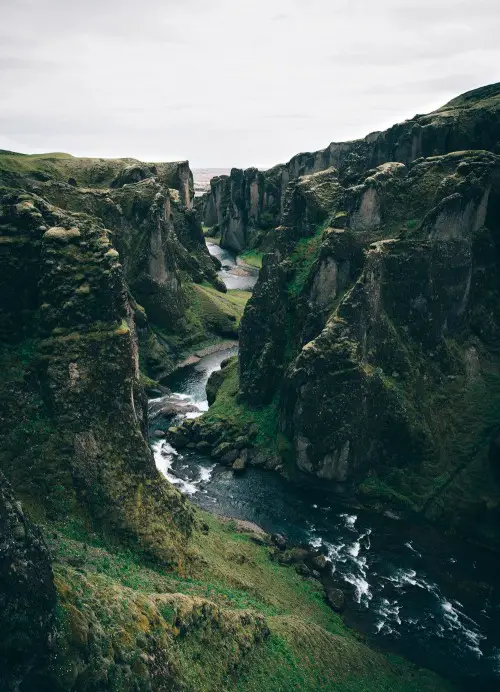
This canyon was prominently featured on a recent Justin Bieber video, sky-rocketing the canyon’s popularity. This led to the subsequent destruction of nature from his fans hoping for re-enactments and selfies for Instagram. All of this promptly caused Bieber to be banned from Iceland.
If Fjaðrárgljúfur Canyon is a desired tourist destination on your itinerary, please observe it and don’t destroy it so that others can also appreciate its beauty for years to come.
Dverghamrar
I am sad that we didn’t have time to stop at the Dwarf Rocks on our recent trip to Iceland. This National Monument is more basalt column formations in Kirkjubauarklaustur village on Ring Road. Folklore declares these cliffs to be homes to dwarfs and elves.
Skaftafell
Skaftafell is a town located in the heart of the glaciers, is home to Vatnakojull National Park, and is a hub for exhilarating glacier tours and hiking activities.
Glaciers at Skaftelfell
Iceland DOES have a lot of ice. In fact, glaciers cover 11% of the land in the country, making a scenic and photographic landscape. The biggest glacier in Iceland, Vatnajokull, is the largest glacier in all of Europe. It is located in the southeast of Iceland and is accessible from the south coast in many areas along Ring Road from Vatnajokull National Park.
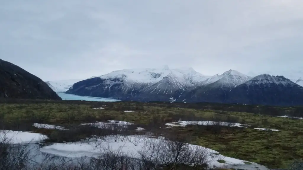
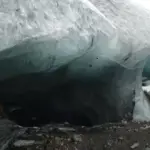
The park is open all year with popular hiking activities in the summer. If you want to explore the popular ice caves, you will need to visit in the winter while the caves are accessible. It is dangerous to walk on glaciers on your own because of all the potential cracks and crevasses that are constantly changing. Hire an experienced guide if your goal is a glacier walk and an ice cave.
See our ICELAND CAVE EXPERIENCE here:
Svartifoss waterfall
Skaftafell contains another beautiful and unique waterfall! After arriving at Vatnajokull National Park, Svartifoss is a relaxing 2-mile round trip hike from the Visitor’s Center and one of the most popular sights in the park. This waterfall, also called Black Falls, is not-to-be-missed because of its unique surrounding dark lava-formed basalt columns, similar to the basalt columns found at Reynisdrangar on the Black Beach.
The Svinafellsjokull glacier provides ice-cold run-off water to feed the waterfall, which plummets 80 feet over the horse-shoe-shaped black column cliffs, resembling the pipes of an organ. The base of the falls is sharp pointy rock since the basalt columns break off faster than the waterfall wears down the jaggedness.
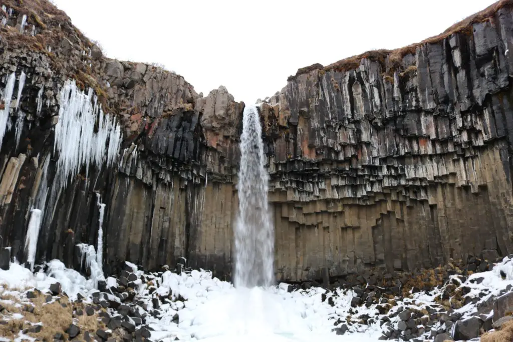
The slightly uphill trail to Svartifoss begins at the Visitor’s Center, goes through the campground, and leads past several other waterfalls before you cross a small bridge and arrive right in front of your final destination. If you don’t turn around after Svartifoss, the trail continues to Sjónarsker, a beautiful viewpoint surrounded by snow-capped mountains.
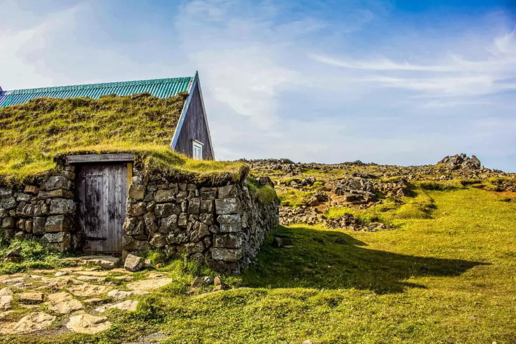
Icelanders have lived in turf houses since the old days, making good use of local materials that they had on hand. They build the houses right into the sides of cliffs.
Viewing the waterfalls and hiking through this National Park is free, but you will have to pay to park. The Visitor’s Center is very nice, with restroom facilities and a restaurant with a large seating area. There is a small souvenir shop, but it was closed when we were there, so I can’t comment on its contents. There are many TRAILS THROUGH SKAFTAFELL, each with sites and beauty to take in.
Must-See Sites!
Vatnajökull Glacier and Jökulsárlón Glacier Lagoon are both in southern Iceland. Nature has created amazing works of art surrounding these two sites and they should both be part of a southern Iceland itinerary. No matter if you are driving on your own or with a tour group, make sure these two are on the list!
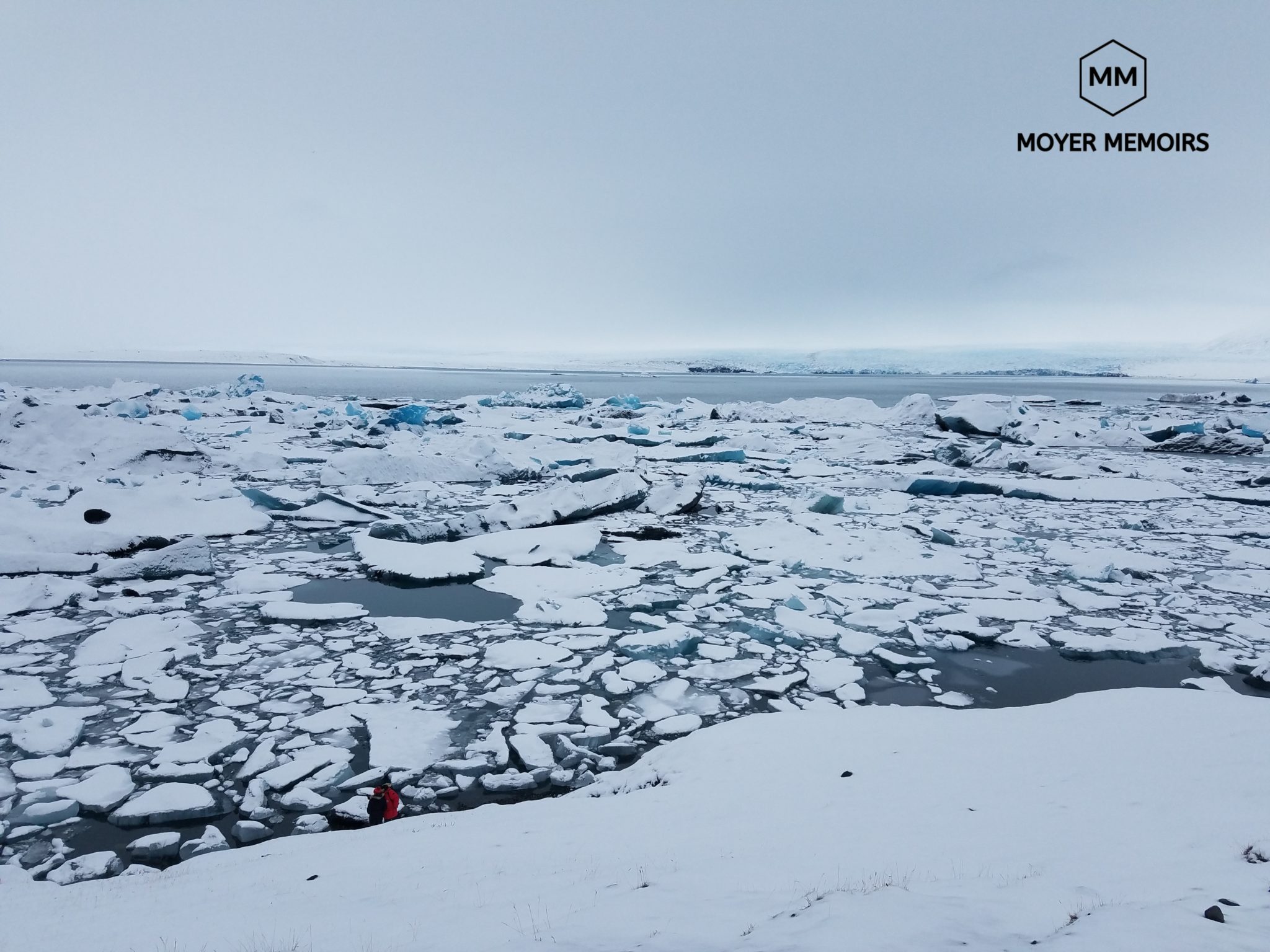
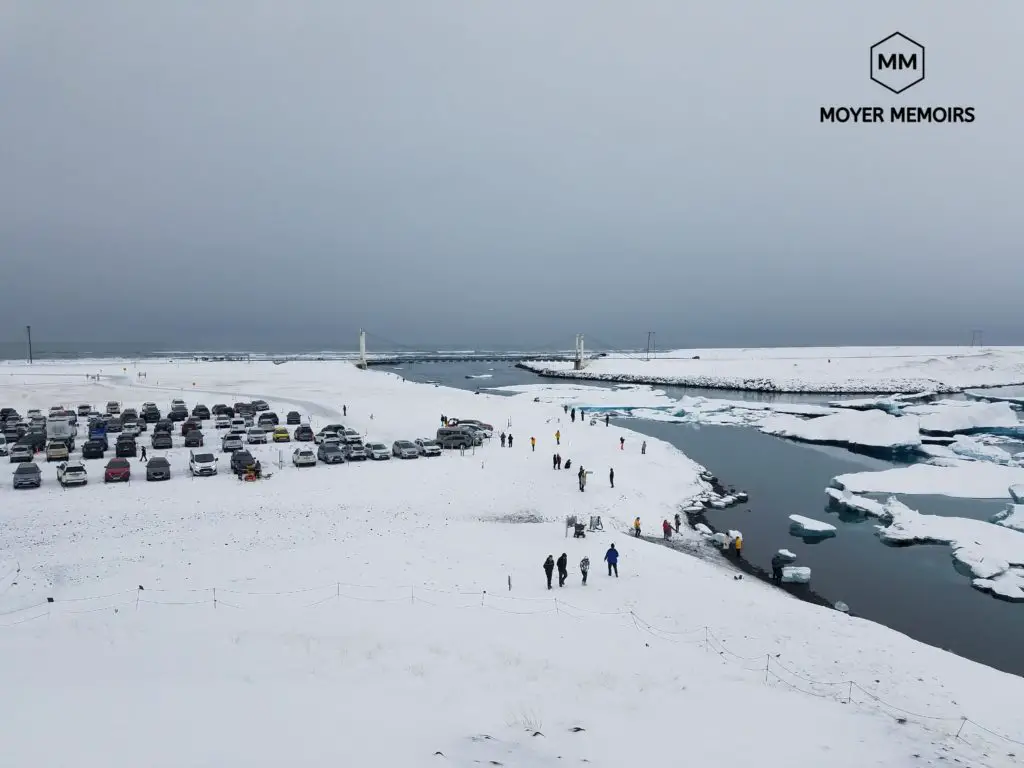
Jokulsarlon Lagoon
Breathtaking and Surreal. These are the words that came to mind as we caught our first glimpse of this lagoon. It is in full view right from Ring Road! It is full of icebergs, small pieces of the larger glacier that have drifted down the lagoon, a little closer to open water, but not quite free yet. The glaciers sparkle with different shades of blue, silver, and white.
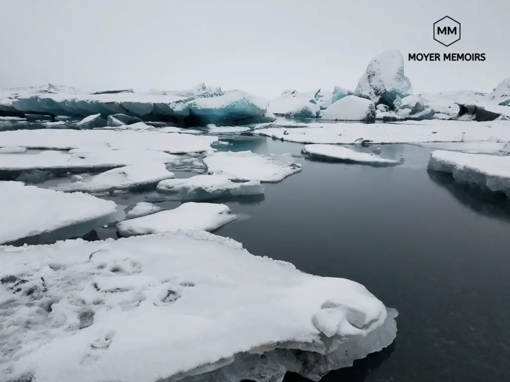
It was actually raining when we were there and very windy, so we got quite a chill. We walked to the top of the hill to survey the whole area. It was difficult due to the rain immediately forming into ice on the steep hill. The view at the top was worth it. The surrounding area was full of icebergs of every size and shape.
We then walked beside the lower part of the lagoon. There were some large ice pieces that were washed ashore like a beached whale. We heard a very loud noise and saw a part of the ice break off in the distance and crash into the water. It was very loud.
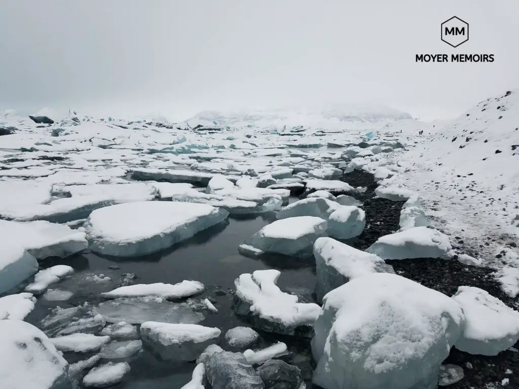
Jokulsarlon is a glacier river lagoon in Vatnajokull National Park and is considered one of the natural wonders of Iceland. The lake was formed only 80 years ago from Breidamerkurjokill glacier and grows each year due to the effects of global warming on the melting glacier. Jokulsarlon has more than tripled since the 1970s as the glacier moves away from Ring Road, leaving its melted remains behind at a break-neck rate of 1500 feet per year.
Ice chunks from Breidamerkujokull Glacier ‘calve’ and fall from the glacier into the lagoon, drifting for up to 5 years before floating out to the Atlantic Ocean. Thousands of tourists visit Jokulsarlon Lagoon each year to see the giant floating icebergs, seemingly motionless in the still water. In the summer, boat tours are offered for close-up views of the Lagoon, the seals that swim about or are relaxing on an iceberg, and the avian wildlife that flourishes in the surroundings.
For safety reasons, do not attempt to climb onto any icebergs. They are 90% submerged underwater so you will have no idea how stable it is or when it could tip over and trap you underneath in the freezing lagoon. The cool picture is not worth the emergency that would happen should that iceberg decide to rearrange itself.

Add an ice cave or glacier hike tour to your itinerary to make a memorable trip!
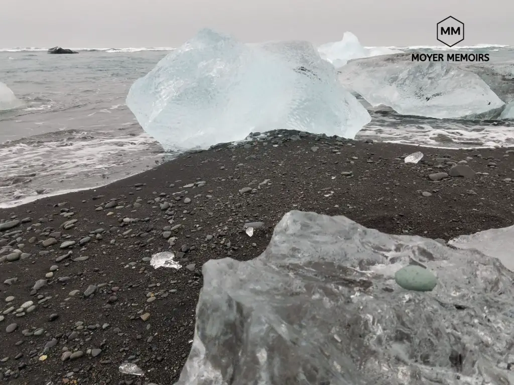
Breiðamerkursandur – Diamond Beach
Diamonds are a girl’s best friend and this was my favorite location in Iceland. This beach has been nicknamed Diamond Beach due to the millions of broken little glacier pieces that have washed ashore on the black sand and glisten like diamonds as the waves wash them back and forth. The icebergs break away, fall into Jökulsárlón Lagoon, drift out to sea, and are shined up by the waves of the North Atlantic before ending up as translucent crystals dotting the black sand at Diamond Beach.
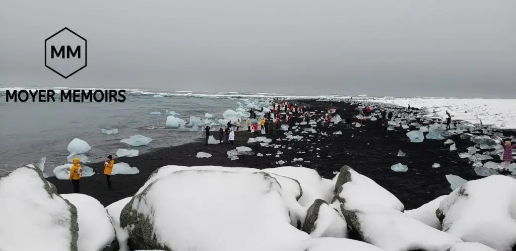
The shards of a once mammoth glacier wash up in different sizes: from a small size that could adorn your wedding ring, to the size of a bathtub.
Diamond Beach is right across the street from the Glacier Lagoon, along the south coast, and a quick turn off of Ring Road. There are two different parking lots, but I recommend the one on the west side of the lagoon because it is bigger and filled with more crystals.
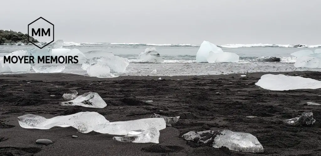
Stay out of the water, as the tide is quick and the waves are unpredictable, and do not place yourself on top of any ice pieces since you never know when they could float back off to sea.
Take millions of selfies at this beautiful natural phenomenon, but consider safety when visiting Diamond Beach. The scenery changes every day as new diamonds wash ashore and what is here now may no longer exist in the future due to global warming.
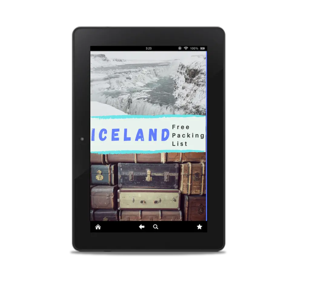
What should I bring on a Ring Road trip?
Ring Road circles Iceland and can be a week-long trip self-drive trip. Be prepared to take along some must-have items on this ICELAND PACKING LIST. Don’t forget a single thing with this detailed list!!
Don’t forget to include these awesome tours in your Iceland itinerary!
Wow, this is absolutely incredible and amazing! The pictures are mind-blowing! Adding Iceland to my bucket list 😍
This is incredible. Iceland was never on my travel bucket list. I think I need to add it 😀
I had no idea about the amount of beauty that this island country had! There is such a variety of discoveries that I had never seen before like the black beaches, glaciers, and much more. It would be a nice addition to your bucket list 😉
These photos are so beautiful! I went to Iceland a few years ago, and these are making me anxious to return. Looks like you had a wonderful trip.
Breathtaking pictures! Looks like an amazing place to visit!
I just told my mom that I wanted to move somewhere cold since this summer is supposed to be the hottest on record. I think I found my new favorite place, though I’m wary of the lava flow. I really want to see the turf-roofed houses in Sjónarsker,
What an awesome ring road trip! I would love to do this and stop at all the waterfalls. Gorgeous pictures! 🙂
it was awesome! and there were so many waterfalls that weren’t the ‘main’ ones that were just as pretty. You drive for a couple of minutes and you see another one… and then another one… it’s endless!
I have always been intrigued by Iceland, but haven’t made the trip (yet). That being said, it’s one of the destinations that I find myself researching regularly. I’ve heard of Ring Road before, but I LOVE seeing through your eyes with all these pictures. Everything looks so incredible!!!
Wow waterfalls galore!!! I would love to visit one day!!
After going to the Faroe Islands I’m desperate to go to Iceland! This post has bumped it up for me I’m just worried about how much it is going to cost!
There are a lot of ways to save some money on an Iceland vacation. Let me know if you want any suggestions.
Wow, this is so awesome. Definitely makes me want to go visit! And such beautiful photos!
Aw! this is what actually a natural wonder is! The places are great and beautiful <3 I feel like I was in Iceland too.
Thanks for sharing! This trip is on my husband bucket list!
I am travel in different place and really amazing information about the Iceland ring road thanks sharing this article
Thanks for sharing this amazing piece of article